


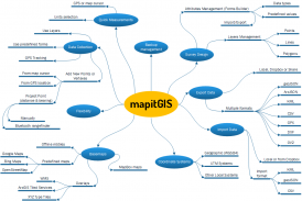
Mapit GIS - Map Data Collector


Mapit GIS - Map Data Collector ਦਾ ਵੇਰਵਾ
ਮੈਪਿਟ ਇਕ ਪ੍ਰੋਫੈਸ਼ਨਲ, ਖੜੇ, ਇਕੱਲੇ, ਲਾਗਤ ਪ੍ਰਭਾਵਸ਼ਾਲੀ ਮੈਪਿੰਗ ਅਤੇ ਸਰਵੇਖਣ ਟੂਲ ਹੈ ਜੋ ਉਤਪਾਦਕਤਾ ਨੂੰ ਵਧਾਉਣ ਲਈ ਤਿਆਰ ਕੀਤਾ ਗਿਆ ਹੈ ਜਦੋਂ ਤੁਸੀਂ ਖੇਤਰ ਵਿਚ ਬਾਹਰ ਰਹਿੰਦੇ ਹੋ.
ਐਪਲੀਕੇਸ਼ ਇਨਪੁਟ ਅਤੇ ਆਉਟਪੁਟ ਲਈ ਆਮ ਫਾਈਲ ਫਾਰਮਾਂ ਦਾ ਸਮਰਥਨ ਕਰਦਾ ਹੈ ਅਤੇ ਬਾਹਰੀ GNSS ਰੀਸੀਵਰਾਂ ਦੇ ਨਾਲ ਕੰਮ ਕਰਨ ਦੇ ਯੋਗ ਹੁੰਦਾ ਹੈ ਤਾਂ ਜੋ ਤੁਹਾਨੂੰ ਸੈਂਟੀਮੀਟਰ ਪੱਧਰ ਦੀ ਸ਼ੁੱਧਤਾ ਮਿਲ ਸਕੇ ਜਦੋਂ ਤੁਹਾਨੂੰ ਲੋੜ ਹੋਵੇ
ਆਪਣੇ ਸਰਵੇਖਣ ਫਾਰਮਾਂ ਨੂੰ ਡਿਜ਼ਾਇਨ ਕਰੋ, ਲੇਅਰਸ ਤੇ ਡਾਟਾ ਸੰਗਠਿਤ ਕਰੋ, ਐਮਬੀਟੀਲਾਂ ਦੇ ਆਧਾਰ-ਮੈਪਸ ਨਾਲ ਔਫਲਾਈਨ ਕੰਮ ਕਰੋ, WMS ਸੇਵਾਵਾਂ ਦੀ ਵਰਤੋਂ ਕਰੋ, ਆਪਣੀ ਲਾਈਨ ਅਤੇ ਬਹੁਭੁਜ ਵਿਸ਼ੇਸ਼ਤਾਵਾਂ ਨੂੰ ਹਾਸਲ ਕਰਨ ਲਈ GPS ਟ੍ਰੈਕਿੰਗ ਵਰਤੋ, GNSS ਮੈਟਾਡੇਟਾ ਰਿਕਾਰਡ ਕਰੋ ਅਤੇ ਹੋਰ ਬਹੁਤ ਕੁਝ ਲੱਭੋ.
ਐਪ ਨੂੰ ਵਿਆਪਕ ਸੰਸਾਰ ਭਰ ਦੇ ਪੇਸ਼ੇਵਰ ਦੁਆਰਾ ਵਰਤਿਆ ਜਾਂਦਾ ਹੈ ਅਤੇ ਇਸਨੂੰ ਖੇਤੀਬਾੜੀ ਅਤੇ ਜੰਗਲਾਤ ਦੇ ਵੱਖ-ਵੱਖ ਐਪਲੀਕੇਸ਼ਨਾਂ ਲਈ ਸੜਕ ਨਿਰਮਾਣ, ਭੂਗੋਲ, ਭੂਮੀ ਸਰਵੇਖਣ ਅਤੇ ਸੋਲਰ ਪੈਨਲ ਦੇ ਹੱਲ ਲਈ ਆਸਾਨੀ ਨਾਲ ਅਪਣਾਇਆ ਜਾ ਸਕਦਾ ਹੈ. ਵਿਅਕਤੀਗਤ ਸੈਟਿੰਗਾਂ ਅਤੇ ਲਚੀਲਾਪਨ ਇਸ ਐਪ ਨੂੰ ਮੰਤਵਾਂ ਦੇ ਲਈ ਅਨੁਕੂਲ ਬਣਾਉਂਦਾ ਹੈ ਜੋ ਤੁਹਾਡੇ ਸਰਵੇਖਣ ਵਰਕਫਲੋ ਵਿੱਚ ਵਾਧਾ ਕਰੇਗਾ.
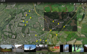
ਖੇਤਰਾਂ ਜਾਂ ਦੂਰੀ ਦਾ ਹਿਸਾਬ ਲਗਾਉਣ ਲਈ ਐਪ ਨੂੰ ਮਾਪਣ ਦੇ ਸਾਧਨ ਵਜੋਂ ਵੀ ਵਰਤਿਆ ਜਾ ਸਕਦਾ ਹੈ
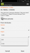
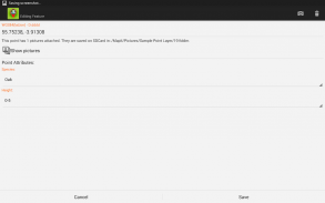
ਸਥਾਨ ਦੀ ਸੰਭਾਲ ਕਰਦੇ ਸਮੇਂ ਪਹਿਲਾਂ ਪਰਿਭਾਸ਼ਿਤ ਡ੍ਰੌਪ ਡਾਉਨ ਲਿਸਟ ਤੋਂ ਲੋੜੀਂਦੇ ਗੁਣਾਂ ਦੀ ਚੋਣ ਕਰਦੇ ਹੋ, ਉਸੇ ਜਾਣਕਾਰੀ ਨੂੰ ਦੁਬਾਰਾ ਅਤੇ ਦੁਬਾਰਾ ਟਾਈਪ ਕਰਨ ਦੀ ਲੋੜ ਨਹੀਂ ਪੈਂਦੀ. ਪਾਠ ਫਾਈਲਾਂ ਦੀਆਂ ਵਿਸ਼ੇਸ਼ਤਾਵਾਂ ਦੀ ਲੰਮੀ ਸੂਚੀ ਆਯਾਤ ਕਰੋ ਅਤੇ ਪ੍ਰੋਜੈਕਟਾਂ ਦੀ ਗਿਣਤੀ ਵਿੱਚ ਉਹਨਾਂ ਨੂੰ ਮੁੜ ਵਰਤੋਂ. ਜੇ ਜਰੂਰੀ ਹੋਵੇ ਤਾਂ ਤੁਸੀਂ ਹਰ ਸਥਾਨ ਤੇ ਤਸਵੀਰਾਂ ਵੀ ਜੋੜ ਸਕਦੇ ਹੋ.
ਜੇ ਤੁਸੀਂ ਖੇਤਰ ਵਿਚ ਕੰਮ ਕਰ ਰਹੇ ਹੋ, ਤਾਂ ਵੱਡੇ ਪੱਧਰ ਦੇ ਡੇਟਾ ਇਕੱਤਰ ਕਰਕੇ ਇਹ ਐਪ ਤੁਹਾਡੇ ਲਈ ਤਿਆਰ ਕੀਤਾ ਗਿਆ ਹੈ.
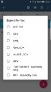
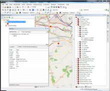
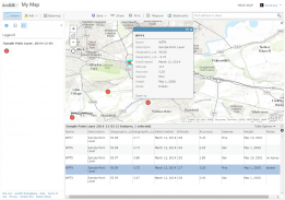
ਆਪਣੇ ਵਰਕਫਲੋ ਨੂੰ ਤੇਜ਼ ਕਰੋ ਅਤੇ ਡੈਟਾ ਕਲੈਕਸ਼ਨ ਨੂੰ ਹੋਰ ਕੁਸ਼ਲ ਬਣਾਓ. ਸਰਵੇਖਣ ਲੇਅਰਾਂ ਦਾ ਫਾਇਦਾ ਉਠਾਓ ਅਤੇ ਕਈ ਸਰਵੇਖਣਾਂ ਲਈ ਵਿਸ਼ੇਸ਼ਤਾਵਾਂ ਦੇ ਉਸੇ ਸਮੂਹ ਨੂੰ ਦੁਬਾਰਾ ਵਰਤਣ ਦੀ ਸੰਭਾਵਨਾ. ਆਪਣੇ ਡਾਟਾ ਨੂੰ ਆਮ ਜੀ ਆਈ ਐੱਸ ਫਾਰਮੈਟਸ ਜਿਵੇਂ ਕਿ ਐਸਸੀਆਈ ਆੱਫ ਫਾਈਲਾਂ, ਸੀਐਸਵੀ, ਕੇਐਲਐਲ, ਜਿਓਜ਼ਨ, ਡੀਐਕਸਐਫ, ਜੀਪੀਐਕਸ ਅਤੇ ਐਕਸੈਸ ਕਰੋ.
ਲੋੜ ਪੈਣ 'ਤੇ ਪੂਰਵ ਪਰਿਭਾਸ਼ਿਤ ਤਾਲਮੇਲ ਪ੍ਰਣਾਲੀਆਂ ਅਤੇ ਅਨੁਕੂਲਿਤ EPSG ਕੋਡਾਂ ਲਈ ਸਮਰਥਨ
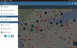
ਮੋਬਾਈਲ ਡਾਟਾ ਇਕੱਠਾ ਕਰਨਾ ਵਿਸ਼ੇਸ਼ਤਾਵਾਂ:
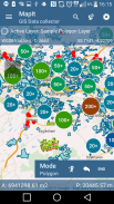
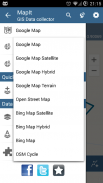
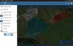
- ਬੇਸ ਨਕਸ਼ੇ: ਪ੍ਰਸਿੱਧ ਆਨਲਾਈਨ ਨਕਸ਼ੇ ਚੋਣ ਅਤੇ ਆਫਲਾਈਨ ਮਲਟੀਲਾਈਟਾਂ,
- RTK ਲਈ ਸਹਾਇਤਾ ਸਹੀ ਨਿਰਦੇਸ਼ ਜਦੋਂ ਬਾਹਰੀ ਬਲਿਊਟੁੱਥ ਜੀਪੀਐਸ / ਜੀਐਨਐਸਐਸ ਨਾਲ ਜੁੜਿਆ ਹੋਇਆ ਹੈ,
- WMS ਅਤੇ GIS ਸਰਵਰ ਲਈ ਸਹਾਇਤਾ ਟਾਇਲਡ ਮੈਪ ਸੇਵਾਵਾਂ - ਭੌਤਿਕ ਵਿਗਿਆਨ ਅਤੇ ਔਰਥੋਫੋਟੋ ਨਕਸ਼ੇ, ਭੂ-ਵਿਗਿਆਨਕ ਸਰਵੇਖਣਾਂ, ਕੈਡਸਟ੍ਰਾਲ ਜਾਣਕਾਰੀ ਅਤੇ ਹੋਰ ਸੇਵਾਵਾਂ ਦੀ ਗਿਣਤੀ ਨੂੰ ਲੋਡ ਕਰੋ.
- ਗੁਣਾਂ ਦੇ ਸੈਟ ਬਣਾਉਣ ਅਤੇ ਕਾਇਮ ਰੱਖਣ ਦੀ ਸੰਭਾਵਨਾ - ਇਹ ਇੱਕ ਡਰਾਪ ਡਾਊਨ ਸੂਚੀਆਂ ਵਜੋਂ ਉਪਲੱਬਧ ਹਨ ਜਦੋਂ ਨਵੀਂ ਫੀਚਰ ਨੂੰ ਰਿਕਾਰਡ ਕੀਤਾ ਜਾ ਰਿਹਾ ਹੈ, ਮੁੱਲ ਦੀਆਂ ਲੰਬੀਆਂ ਸੂਚੀਆਂ ਟੈਕਸਟ ਫਾਈਲਾਂ ਤੋਂ ਆਯਾਤ ਕੀਤੀਆਂ ਜਾ ਸਕਦੀਆਂ ਹਨ.
- ਬਿੰਦੂ ਮੈਪ ਮਾਰਕਰਸ ਲਈ ਕਲੱਸਟਰ, ਕਾਰਗੁਜ਼ਾਰੀ ਦੇ ਮੁੱਦਿਆਂ ਦੇ ਬਿਨਾਂ ਨਕਸ਼ੇ 'ਤੇ ਵੱਡੀ ਗਿਣਤੀ ਵਿੱਚ ਪੁਆਇੰਟ ਬਣਾਉਣ ਦੇ ਕਾਰਗਰ ਤਰੀਕੇ,
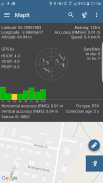
- ਵਰਤਮਾਨ ਵਿੱਚ ਕੁਲੈਕਸ਼ਨ ਦੇ 4 ਢੰਗ ਸਮਰਥਿਤ ਹਨ (GPS / GNSS ਦੀ ਸਥਿਤੀ, ਮੈਪ ਕਰਸਰ ਦੀ ਸਥਿਤੀ, ਟਰੈਕਿੰਗ, ਬਿੰਦੂ ਪ੍ਰਸੰਸਾ ਕੋਣ ਅਤੇ ਦੂਰੀ ਨਾਲ),
- ਤੁਹਾਡੇ ਡਾਟਾ ਨੂੰ ਸਰਵੇਖਣ ਲੇਅਰਾਂ ਵਿੱਚ ਜੋੜਨ ਦੀ ਸੰਭਾਵਨਾ - ਹਰੇਕ ਸਰਵੇਖਣ ਪਰਤ ਵਿੱਚ ਵਿਸ਼ੇਸ਼ਤਾਵਾਂ ਦਾ ਇੱਕ ਡਿਫਾਲਟ ਸੈਟ ਹੋ ਸਕਦਾ ਹੈ
- ਸਥਾਨਕ ਐਸਡੀ ਕਾਰਡ ਜਾਂ ਰਿਮੋਟ ਨਿਰਯਾਤ ਇਸ ਵੇਲੇ ਆਕਾਰ ਦੀਆਂ ਫਾਈਲਾਂ, ਕੇਐਲਐਲ, ਸੀਐਸਵੀ, ਜੀਓਜ਼ਨ, ਜੀਪੀਐਕਸ ਅਤੇ ਡੀਐਸਐਫ ਐਕਸਪੋਰਟ ਦੀ ਸਹਾਇਤਾ ਕੀਤੀ ਜਾਂਦੀ ਹੈ,
- ਡ੍ਰੌਪਬਾਕਸ ਜਾਂ FTP ਟਿਕਾਣੇ ਤੇ ਸਿੱਧਾ ਨਿਰਯਾਤ
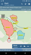
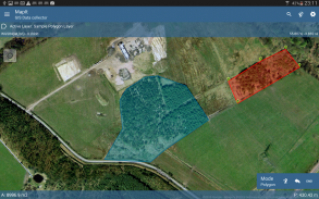
- ਇਕ ਲੇਅਰ 'ਤੇ ਮਲਟੀਪਲ ਪੁਆਇੰਟ, ਰੇਖਾਵਾਂ ਅਤੇ ਬਹੁਭੁਜਾਂ ਨੂੰ ਰਿਕਾਰਡ ਕਰਨ ਦੀ ਸੰਭਾਵਨਾ,
- ਜਦੋਂ ਨਵਾਂ ਬਹੁਭੁਜ ਬਣਾਉਣਾ ਹੋਵੇ ਜਾਂ ਰੇਖਾ ਵਿਸ਼ੇਸ਼ਤਾਵਾਂ ਦੇ ਮਾਪਾਂ ਦੇ ਵੇਰਵੇ ਜਿਵੇਂ ਕਿ ਖੇਤਰ ਜਾਂ ਲੰਬਾਈ ਵੀ ਉਪਲਬਧ ਹਨ.
- GPS / GNSS ਅਤੇ ਸੈਟੇਲਾਈਟ ਦੀ ਸਥਿਤੀ,
- ਪਤਾ, ਸਥਾਨ ਦੀ ਭਾਲ,
- ਬਿੰਦੂ, ਲਾਈਨ ਅਤੇ ਬਹੁਭੁਜ ਵਿਸ਼ੇਸ਼ਤਾਵਾਂ ਨੂੰ ਸੀਐਸਵੀ, ਕੇਐਲਐਲ, ਆਕਾਰਫਾਇਲ ਜਾਂ ਜਿਓਜ਼ਨਸ ਫਾਇਲ ਤੋਂ ਲੇਅਰ ਵਿੱਚ ਅਯਾਤ ਕਰੋ,
- ਬੈਕਅੱਪ ਪ੍ਰਬੰਧਨ,
- ਫਾਇਲ ਤੋਂ ਅਯਾਤ / ਨਿਰਯਾਤ ਗੁਣਾਂ ਅਤੇ ਹੋਰ ਖੋਜ ਕਰਨ ਲਈ ...
ਸਾਡੇ ਉਪਯੋਗਕਰਤਾ ਸਫਲਤਾ ਨਾਲ Mapit ਦੀ ਵਰਤੋ ਸਮੇਤ ਐਪਲੀਕੇਸ਼ਨਾਂ ਦੀ ਸੰਖਿਆ ਵਿੱਚ ਸ਼ਾਮਲ ਹਨ:
- ਵਾਤਾਵਰਣ ਅਤੇ ਜੰਗਲੀ ਸਰਵੇਖਣ,
- ਜੰਗਲਾਤ ਦੀ ਯੋਜਨਾਬੰਦੀ ਅਤੇ ਵਣਜ ਪ੍ਰਬੰਧਨ,
- ਖੇਤੀਬਾੜੀ ਅਤੇ ਮਿੱਟੀ ਵਰਗੀਕਰਨ ਅਤੇ ਸੈਂਪਲਿੰਗ,
- ਸੜਕ ਨਿਰਮਾਣ,
- ਭੂਮੀ ਸਰਵੇਖਣ,
- ਸੋਲਰ ਪੈਨਲ ਐਪਲੀਕੇਸ਼ਨ,
- ਛੱਤ ਅਤੇ ਵਾੜ,
- ਟ੍ਰੀ ਸਰਵੇਖਣ,
- GPS ਅਤੇ GNSS ਸਰਵੇਖਣ,
- ਸਾਈਟ ਸਰਵੇਖਣ
- ਬਰਫ਼ ਹਟਾਉਣ
ਸਾਡੀ ਵੈਬਸਾਈਟ 'ਤੇ ਸਿੱਧੇ ਜਾਂ ਸੰਪਰਕ ਫਾਰਮ ਦੀ ਵਰਤੋਂ ਕਰਨ ਤੋਂ ਸੰਕੋਚ ਨਾ ਕਰੋ.
Mapit GIS - Map Data Collector - ਵਰਜਨ 7.8.0.0Core
(16-08-2021)

Mapit GIS - Map Data Collector - ਏਪੀਕੇ ਜਾਣਕਾਰੀ
ਏਪੀਕੇ ਵਰਜਨ: 7.8.0.0Coreਪੈਕੇਜ: com.osedok.gisdatacollectorMapit GIS - Map Data Collector ਦਾ ਨਵਾਂ ਵਰਜਨ
ਹੋਰ ਵਰਜਨ


ਇੱਕੋ ਸ਼੍ਰੇਣੀ ਵਾਲਿਆਂ ਐਪਾਂ

ਤੁਹਾਨੂੰ ਇਹ ਵੀ ਪਸੰਦ ਹੋ ਸਕਦਾ ਹੈ...


